Butun axtardiqlarinizi tapmaq ucun buraya: DAXIL OLUN
  Mp4 Mp3 Axtar Yukle
  Video Axtar Yukle
  Shekil Axtar Yukle
  Informasiya Melumat Axtar
  Hazir Inshalar Toplusu
  AZERI CHAT + Tanishliq
  Saglamliq Tibbi Melumat
  Whatsapp Plus Yukle(Yeni)

  • Ana səhifə
  • Təsadüfi
  • Yaxınlıqdakılar
  • Daxil ol
  • Nizamlamalar
İndi ianə et Əgər Vikipediya sizin üçün faydalıdırsa, bu gün ianə edin.

Fayl:Global soils map USDA.jpg

  • Fayl
  • Müzakirə
  • Fayl
  • Faylın tarixçəsi
  • Faylın istifadəsi
  • Faylın qlobal istifadəsi
  • Metaməlumatlar
Fayl:Global soils map USDA.jpg
Sınaq göstərişi ölçüsü: 773 × 599 piksel. Digər ölçülər: 310 × 240 piksel | 619 × 480 piksel | 991 × 768 piksel | 1.280 × 992 piksel | 2.560 × 1.985 piksel | 6.165 × 4.780 piksel.
Faylın orijinalı (6.165 × 4.780 piksel, fayl həcmi: 6,67 MB, MIME növü: image/jpeg)
Bu fayl Vikianbarda yerləşir. Açıqlama səhifəsindəki məlumatlar aşağıda göstərilib.
Vikianbar azad lisenziyalı media anbarıdır. Siz də töhfə verə bilərsiniz.

Xülasə

İzahGlobal soils map USDA.jpg
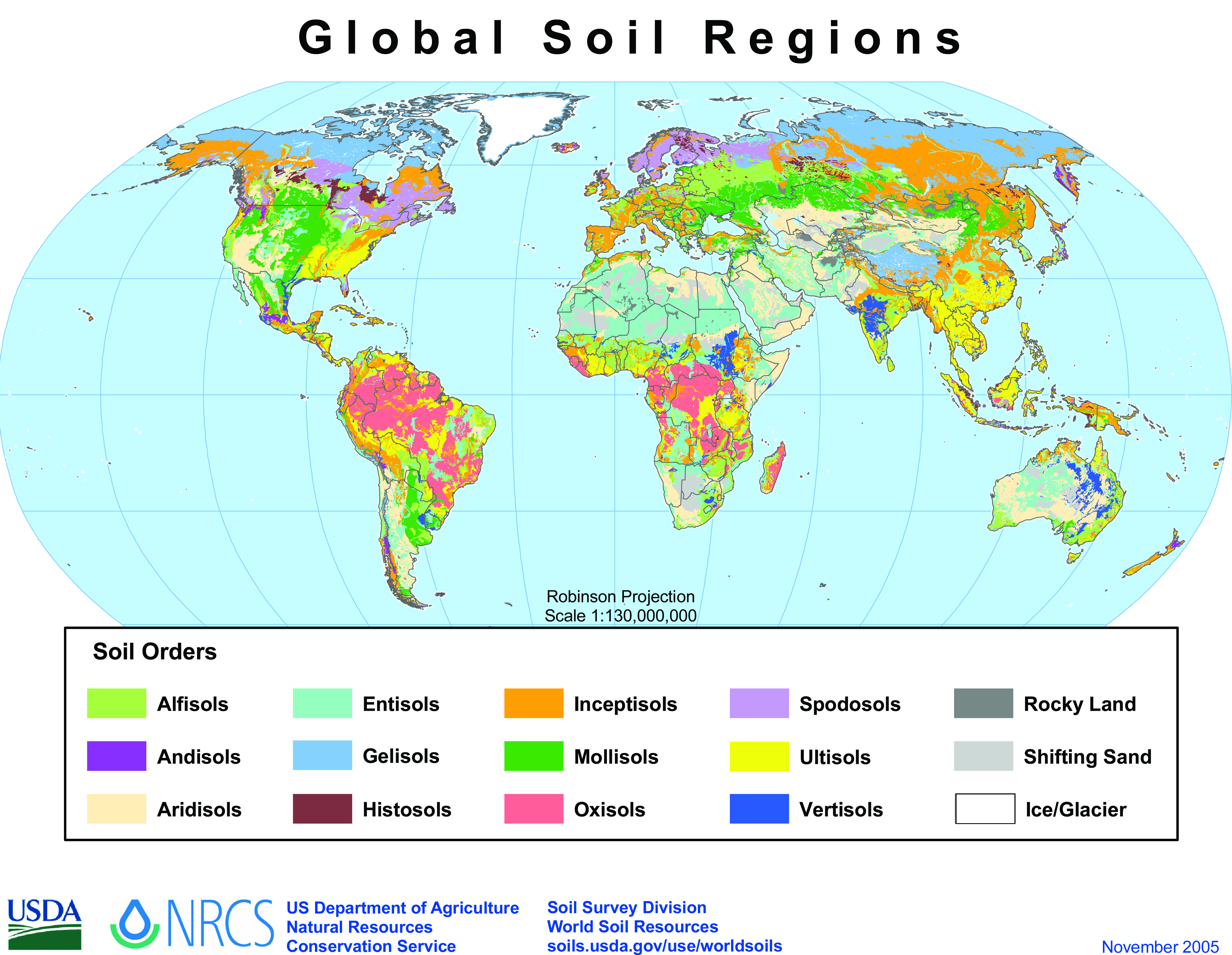
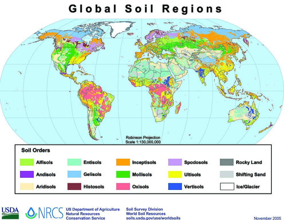
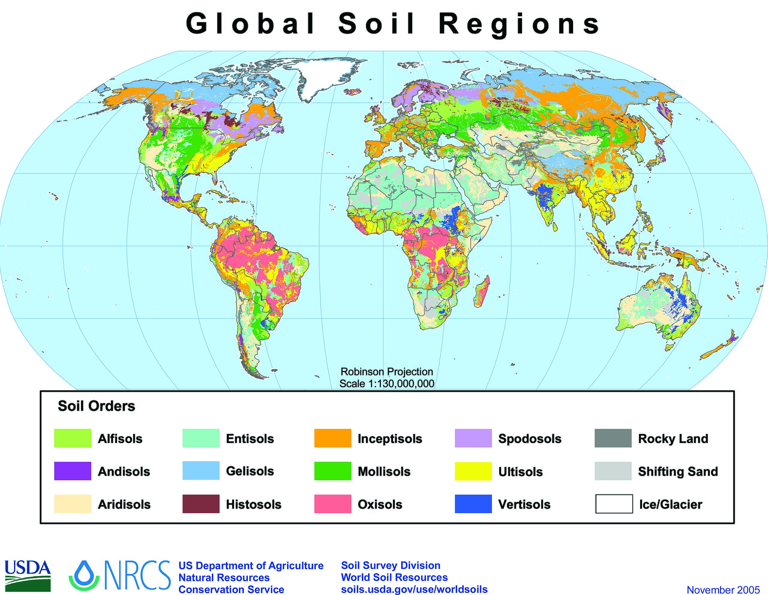
English: A map of global soils according to U.S. soil taxation system.
Tarix noyabr 2005
Mənbə https://soils.usda.gov/use/worldsoils/mapindex/order.html
Müəllif Natural Resources Conservation Service / USDA
This map image could be re-created using vector graphics as an SVG file. This has several advantages; see Commons:Media for cleanup for more information. If an SVG form of this image is available, please upload it and afterwards replace this template with {{vector version available|new image name}}.
It is recommended to name the SVG file “Global soils map USDA.svg”—then the template Vector version available (or Vva) does not need the new image name parameter.
This map image was uploaded in the JPEG format even though it consists of non-photographic data. This information could be stored more efficiently or accurately in the PNG or SVG format. If possible, please upload a PNG or SVG version of this image without compression artifacts, derived from a non-JPEG source (or with existing artifacts removed). After doing so, please tag the JPEG version with {{Superseded|NewImage.ext}} and remove this tag. This tag should not be applied to photographs or scans. If this image is a diagram or other image suitable for vectorisation, please tag this image with {{Convert to SVG}} instead of {{BadJPEG}}. If not suitable for vectorisation, use {{Convert to PNG}}. For more information, see {{BadJPEG}}.

Lisenziya

Public domainPublic domainfalsefalse
Public domain
This image or file is a work of a United States Department of Agriculture employee, taken or made as part of that person's official duties. As a work of the U.S. federal government, the image is in the public domain.

English ∙ español ∙ 日本語 ∙ 한국어 ∙ македонски ∙ Nederlands ∙ русский ∙ slovenščina ∙ українська ∙ Tiếng Việt ∙ 中文(中国大陆) ∙ 中文(繁體) ∙ +/−

Başlıqlar

Bu faylın nəyi təmsil etdiyinə dair bir sətirlik izahat əlavə et

Bu faylda təsvir olunan elementlər

təsvir edir

copyright status ingilis

ictimai mülkiyyət

yurisdiksiyasındadır: Amerika Birləşmiş Ştatları
təyinetmə üsulu: work of the federal government of the United States ingilis

Faylın tarixçəsi

Faylın əvvəlki versiyasını görmək üçün gün/tarix bölməsindəki tarixlərə klikləyin.

Tarix/VaxtMiniatürÖlçülərİstifadəçiŞərh
hal-hazırkı16:00, 21 oktyabr 201316:00, 21 oktyabr 2013 tarixindəki versiyanın miniatür görüntüsü6.165 × 4.780 (6,67 MB)Keitsisthigher resolution, higher legibility version directly from the same USDA source page
22:34, 9 yanvar 200922:34, 9 yanvar 2009 tarixindəki versiyanın miniatür görüntüsü1.194 × 766 (109 KB)Paisano flaco{{Information |Description={{en|1=map of global soils according to US soil taxation system, retrieved from : http://soils.usda.gov/use/worldsoils/mapindex/order.html}} |Source=Natural Resources Conservation Service / US Department of Agriculture |Author=h

Faylın istifadəsi

Aşağıdakı səhifə bu faylı istifadə edir:

  • Torpaq coğrafiyası

Faylın qlobal istifadəsi

Bu fayl aşağıdakı vikilərdə istifadə olunur:

  • ar.wikipedia.org layihəsində istifadəsi
    • نظام تصنيف التربة الأمريكي
  • azb.wikipedia.org layihəsində istifadəsi
    • تورپاق جوغرافیاسی
  • ca.wikipedia.org layihəsində istifadəsi
    • Ciència del sòl
    • Classificació dels sòls del Departament d'Agricultura dels Estats Units
  • da.wikipedia.org layihəsində istifadəsi
    • Geologi
    • Jordklassifikation
    • USDA jordklassifikation
  • de.wikipedia.org layihəsində istifadəsi
    • Gran Chaco
  • en.wikipedia.org layihəsində istifadəsi
    • Soil science
    • Soil type
    • USDA soil taxonomy
    • Soil classification
    • Soil fertility
    • Soil morphology
    • List of Russian explorers
    • Indian Institute of Soil Science
  • en.wikibooks.org layihəsində istifadəsi
    • Planet Earth/7h. Soil: Living Dirt
    • Planet Earth/print version
  • es.wikipedia.org layihəsində istifadəsi
    • Región Occidental del Paraguay
    • Ciencia del suelo
    • Edafogeografía
    • Categoría:Ciencias del suelo
    • Fertilidad del suelo
  • et.wikipedia.org layihəsində istifadəsi
    • Mullageograafia
  • fr.wikipedia.org layihəsində istifadəsi
    • Sol (pédologie)
    • Classification américaine des sols
  • hy.wikipedia.org layihəsində istifadəsi
    • Հողային քարտեզներ
    • Հողագիտություն
  • ja.wikipedia.org layihəsində istifadəsi
    • 土壌学
    • 土壌分類
    • 土壌肥沃度
  • kk.wikipedia.org layihəsində istifadəsi
    • Топырақ географиясы
  • ko.wikipedia.org layihəsində istifadəsi
    • 토양구
    • 러시아의 탐험가 목록
  • kw.wikipedia.org layihəsində istifadəsi
    • Gweres
  • ky.wikipedia.org layihəsində istifadəsi
    • Топурак географиясы
  • la.wikipedia.org layihəsində istifadəsi
    • Scientia solorum
  • mn.wikipedia.org layihəsində istifadəsi
    • Загвар:Soil-sci-stub
    • Австрали дахь давсжилт
  • mr.wikipedia.org layihəsində istifadəsi
    • माती विज्ञान
  • pa.wikipedia.org layihəsində istifadəsi
    • ਮਿੱਟੀ ਦੀ ਉਪਜਾਊ ਸ਼ਕਤੀ
  • pnb.wikipedia.org layihəsində istifadəsi
    • زمین دی زرخیزی
  • pt.wikipedia.org layihəsində istifadəsi
    • Taxonomia dos Solos do USDA
  • rm.wikipedia.org layihəsində istifadəsi
    • Terren
  • simple.wikipedia.org layihəsində istifadəsi
    • Soil science
  • sr.wikipedia.org layihəsində istifadəsi
    • Nauka o tlu
  • uk.wikipedia.org layihəsində istifadəsi
    • Географія ґрунтів
    • Ґрунтовий покрив
  • uz.wikipedia.org layihəsində istifadəsi
    • Tuproq unumdorligi
  • vi.wikipedia.org layihəsində istifadəsi
    • Độ phì đất

Bu faylın qlobal istifadəsinə baxın.

Metaməlumatlar

Bu faylda fotoaparat və ya skanerlə əlavə olunmuş məlumatlar var. Əgər fayl sonradan olunubsa, bəzi parametrlər bu şəkildə göstərilənlərdən fərqli ola bilər.

OrientasiyaNormal
Üfüqi xətt600 dpi
Şaquli xətt600 dpi
Proqram təminatıAdobe Photoshop CS2 Windows
Faylın dəyişməsi tarixi və vaxtı10:49, 1 noyabr 2005
Rəng sahəsiFotoşəkildə rəng seçimi edilməmişdir.
Şəkilin eni6.165 px
Şəkilin hündürlüyü4.780 px
Tarix və vaxt rəqəmləşdirilir05:49, 1 noyabr 2005
Date metadata was last modified05:49, 1 noyabr 2005
Mənbə — "https://az.wikipedia.org/wiki/Fayl:Global_soils_map_USDA.jpg"
Informasiya Melumat Axtar