Category:Brixton, London
district in the London Borough of Lambeth, South London, England  Rue de Brixton (2010) | |||||
| Upload media | |||||
| Instance of | |||||
|---|---|---|---|---|---|
| Location | London Borough of Lambeth, Greater London, London, England | ||||
| Population |
| ||||
 | |||||
Subcategories
This category has the following 43 subcategories, out of 43 total.
A
- Ashby's Mill, Brixton (29 F)
B
- Beehive Place, London (3 F)
- Brixton Bus Garage (11 F)
- Brixton Library (25 F)
C
E
F
- Ferndale Road, London (6 F)
G
H
J
- Jaja Soze (7 F)
L
- Leeson Road, Brixton (1 F)
M
- Mausoleum of Richard Budd (13 F)
- Max Roach Park (10 F)
N
P
- Pope's Road, Brixton (9 F)
R
S
- Southwyck House (4 F)
- Stansfield Road, London (2 F)
V
- Villa Road, London (5 F)
W
Media in category "Brixton, London"
The following 183 files are in this category, out of 183 total.
-
De-Brixton.ogg 1.9 s; 17 KB
-
 "First Child" sculpture, Max Roach Park, Brixton, London, UK.jpg 8,160 × 6,120; 19.19 MB
-
 1881 England Census, Effra Road, Brixton, Lambeth, London.PNG 937 × 651; 1.14 MB
-
 1888 Map of Herne Hill, North Dulwich, East Dulwich, Champion Hill, Knight's Hill.jpg 1,188 × 1,163; 1.42 MB
-
 43 Effra Road, Brixton - geograph.org.uk - 2707715.jpg 4,288 × 3,216; 6.56 MB
-
 45 Effra Road, Brixton - geograph.org.uk - 2707717.jpg 4,288 × 3,216; 6.13 MB
-
 Advert for airship excursions Wellcome V0050583.jpg 3,070 × 2,325; 2.51 MB
-
 Arriva London - EE1 - Route SL6.jpg 5,184 × 3,456; 5.9 MB
-
 Arriva London - ES134 - Route 196.jpg 5,184 × 3,456; 5.7 MB
-
 Arriva London VLA32 on Route 432, Brixton (16415182771).jpg 3,264 × 2,448; 2.66 MB
-
 At Brixton, London 2025 027.jpg 5,489 × 7,319; 15.5 MB
-
 At Brixton, London 2025 028.jpg 8,064 × 6,048; 18.06 MB
-
 At Brixton, London 2025 029.jpg 8,064 × 6,048; 16.06 MB
-
 At Brixton, London 2025 030.jpg 7,321 × 5,491; 12.31 MB
-
 At Brixton, London 2025 031.jpg 3,024 × 4,032; 3.89 MB
-
 Barnwell Rd - geograph.org.uk - 5811124.jpg 1,024 × 681; 173 KB
-
 Barnwell Road - geograph.org.uk - 4975693.jpg 640 × 427; 118 KB
-
 Baytree Rd - geograph.org.uk - 5800241.jpg 640 × 426; 86 KB
-
 Bellefield Road, Brixton - geograph.org.uk - 4577190.jpg 2,272 × 1,704; 868 KB
-
 Beverstone Road, Brixton - geograph.org.uk - 4577233.jpg 2,272 × 1,704; 957 KB
-
 Blauer Mantel, blaue Jeans.jpg 1,920 × 2,857; 3.95 MB
-
 Blenheim Gardens meets Brixton Hill - geograph.org.uk - 5800168.jpg 640 × 426; 105 KB
-
 Blenheim Gardens, Brixton - geograph.org.uk - 4577262.jpg 2,272 × 1,704; 900 KB
-
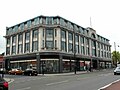
 Bon Marché Brixton.jpg 4,012 × 3,008; 5.59 MB
-
 Brief Street - geograph.org.uk - 3539848.jpg 640 × 480; 375 KB
-
 Brighton Terrace - geograph.org.uk - 5806416.jpg 640 × 426; 91 KB
-

-
 Brixton - Hill & Road junction - war memorial - panoramio.jpg 896 × 672; 160 KB
-
 Brixton - Town Hall near Brixton Oval - panoramio.jpg 896 × 672; 181 KB
-
 Brixton bombing damage 1916 IWM HO 98.jpg 642 × 800; 99 KB
-
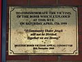 Brixton bombing plaque.jpg 4,000 × 3,000; 4.73 MB
-
 Brixton Breezeblock Cafe.jpg 3,024 × 4,032; 2.11 MB
-

-
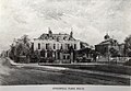
 Brixton Fire Station.jpg 4,032 × 3,024; 4.14 MB
-
 Brixton fire, 1910.jpg 4,232 × 2,784; 5.23 MB
-
 Brixton from the air - geograph.org.uk - 2795093.jpg 640 × 480; 200 KB
-
 Brixton from the air - geograph.org.uk - 2795124.jpg 480 × 640; 216 KB
-
 Brixton from the air - geograph.org.uk - 4544375.jpg 640 × 480; 243 KB
-
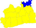 Brixton Hundred - Surrey.svg 1,040 × 821; 122 KB
-
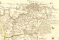 Brixton Hundred.jpg 640 × 440; 101 KB
-
 Brixton Library - Tate Central Free Public Library, December 2024.jpg 4,488 × 3,366; 6.12 MB
-
 Brixton London.jpg 869 × 1,884; 237 KB
-
 Brixton market food shop.JPG 1,600 × 1,200; 439 KB
-
 Brixton Market Store - panoramio.jpg 2,456 × 1,633; 1.25 MB
-

-
 Brixton Orchard.jpg 5,738 × 3,858; 9.64 MB
-
 Brixton Recreation Centre 2, September 2025 01.jpg 6,120 × 8,160; 11.86 MB
-
 Brixton Recreation Centre, September 2025.jpg 8,160 × 6,120; 13.83 MB
-
 Brixton Riots, 200 strong mob.jpg 858 × 570; 92 KB
-
 Brixton Riots, A looter hides from police whilst filling her bag.jpg 570 × 858; 56 KB
-
 Brixton Riots, A Looter runs towards Acre Lane Brixton.jpg 570 × 858; 60 KB
-
 Brixton Riots, A police Sgt explains what is going on.jpg 570 × 858; 61 KB
-
 Brixton Riots, Behind police lines.jpg 858 × 570; 62 KB
-
 Brixton Riots, Brixton - broken.jpg 570 × 858; 84 KB
-

-
 Brixton Riots, H&M Brixton Road- Looted.jpg 570 × 858; 82 KB
-
 Brixton Riots, In the middle of the mele.jpg 858 × 570; 64 KB
-
 Brixton Riots, KFC Brixton's till snatch - broken till.jpg 858 × 570; 75 KB
-
 Brixton Riots, KFC Brixton's till snatch - empty cash drawer.jpg 858 × 570; 72 KB
-
 Brixton Riots, KFC's till snatch - empty cash drawer.jpg 858 × 570; 79 KB
-
 Brixton Riots, Looter and cyclist make off.jpg 570 × 858; 60 KB
-

-
 Brixton Riots, Police begin to assemble in Coldharbour Lane.jpg 858 × 570; 65 KB
-

-

-
 Brixton Riots, Police hold their line on Coldharbour Lane.jpg 858 × 570; 66 KB
-
 Brixton Riots, Police identify their targets.jpg 858 × 570; 71 KB
-
 Brixton Riots, Police make their way down Brixton's High Street.jpg 858 × 570; 409 KB
-
 Brixton Stairs.jpg 3,024 × 4,032; 4.59 MB
-
 Brixton Station Road, September 2025.jpg 3,366 × 4,488; 6.4 MB
-
 Brixton Synagogue (2).jpg 3,840 × 2,160; 3.31 MB
-
 Brixton Town Hall and Palladium in 1916.jpg 4,376 × 2,880; 6.05 MB
-
 Brixton Uprising loo shield (7536831522).jpg 3,264 × 2,448; 684 KB
-
 Brixton Village and Sanitary Steam Laundry 2024-06-29.jpg 4,032 × 3,024; 3.27 MB
-
 Brixton water tower 1.jpg 3,024 × 4,032; 2.08 MB
-
 Brixton water tower 2.jpg 3,024 × 4,032; 1.68 MB
-
 Brixton, Elm Park - geograph.org.uk - 3043350.jpg 3,174 × 2,334; 5.23 MB
-
 Brixton, Helix Road - geograph.org.uk - 3043339.jpg 3,264 × 2,448; 4.5 MB
-
 Brixton, House on Beechdale Road - geograph.org.uk - 3043336.jpg 3,264 × 2,448; 4.63 MB
-
 Brixton- Archbishop's Place (2095818438).jpg 2,448 × 1,836; 782 KB
-
 Chantrey Road - Brixton - geograph.org.uk - 2711100.jpg 495 × 640; 78 KB
-
 Chaucer Rd - geograph.org.uk - 5811171.jpg 1,024 × 681; 197 KB
-
 Church - Our Lady of the Rosary, Brixton - September 2025.jpg 8,076 × 6,008; 12.61 MB
-
 Concanon Road, SW2 - geograph.org.uk - 359569.jpg 640 × 480; 75 KB
-
 Corrance Road, Brixton - geograph.org.uk - 4171882.jpg 800 × 600; 111 KB
-
 Corry Drive, Brixton (1) - geograph.org.uk - 4405008.jpg 1,024 × 768; 118 KB
-
 Corry Drive, Brixton (2) - geograph.org.uk - 4405015.jpg 1,024 × 768; 104 KB
-
 Dispensary; Robsart Dispensary Handbill. Wellcome L0000975.jpg 1,186 × 1,600; 673 KB
-
 Dover House, Cormont Road - geograph.org.uk - 3539747.jpg 640 × 480; 410 KB
-
 E Scott & Co, Brixton Carriage Works, 53 Acre Lane, Brixton SW2 - 1932 (6590420201).jpg 1,600 × 1,251; 234 KB
-
 Effra Parade - geograph.org.uk - 5811164.jpg 1,024 × 681; 157 KB
-
 Effra Parade, SW2 - geograph.org.uk - 380922.jpg 640 × 480; 103 KB
-
 Effra Road - geograph.org.uk - 4975853.jpg 640 × 427; 125 KB
-
 Electric Brixton Concert Hall - october 2023.jpg 1,568 × 974; 246 KB
-
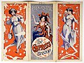 Empress Theatre Brixton programme 1915.jpg 768 × 574; 143 KB
-
 Filming an episode of "The Bill" - P1050483.jpg 3,072 × 2,304; 3.46 MB
-

-
 Forecourt Wall, Railings, Gate Piers And Gates At Former St John's School.jpg 4,032 × 3,024; 5.98 MB
-
 Forensic services vans Canterbury Crescent, Brixton 2024-06-29.jpg 4,032 × 3,024; 4.07 MB
-
 Former St John's Church Of England School.jpg 4,032 × 3,024; 4.29 MB
-
 FriendshipHouseBelvedere-03.jpg 512 × 683; 135 KB
-
 Front of Brixton Synagogue (1913-1986) - October 2023.jpg 1,136 × 872; 236 KB
-

-
 Gateley Road, Brixton - geograph.org.uk - 4577179.jpg 2,272 × 1,704; 815 KB
-
 Geordie Greep, The Windmill Brixton , London, 30 March 2024 (cropped).jpg 3,385 × 4,208; 12.31 MB
-
 Geordie Greep, The Windmill Brixton , London, 30 March 2024.jpg 5,504 × 5,504; 25.16 MB
-
 Glendall Street, Brixton - geograph.org.uk - 4577195.jpg 2,272 × 1,704; 817 KB
-
 Glendall Street, SW9 - geograph.org.uk - 2309059.jpg 640 × 481; 63 KB
-
 Gothic in Brixton - geograph.org.uk - 2636859.jpg 4,000 × 3,000; 4.21 MB
-
 Hackford Road, Brixton - geograph.org.uk - 4578143.jpg 2,272 × 1,704; 938 KB
-
 Hallwell Rd - geograph.org.uk - 5800152.jpg 640 × 426; 66 KB
-
 Haus mit Pferdekopf in Brixton, London.jpg 1,200 × 1,600; 121 KB
-
 Hayter Rd - geograph.org.uk - 5800229.jpg 640 × 426; 64 KB
-
 Hayter Road, Brixton - geograph.org.uk - 4577234.jpg 2,272 × 1,704; 795 KB
-
 Helix Avenue at the junction with Brixton Water Lane - geograph.org.uk - 3755896.jpg 2,560 × 1,920; 2.52 MB
-
 Henry Iving memorial in Brixton, London.jpg 2,048 × 1,536; 418 KB
-
 Horsford Rd - geograph.org.uk - 5800208.jpg 640 × 426; 65 KB
-
 House in front of Brixton police station with placards in window.jpg 3,024 × 4,032; 3.47 MB
-
 Info about "First Child" sculpture, Max Roach Park, Brixton, London, UK 01.jpg 8,160 × 6,120; 11.3 MB
-

-
 Ivor House (8714202585).jpg 3,648 × 2,736; 3.07 MB
-
 Josephine Avenue - geograph.org.uk - 5800194.jpg 640 × 425; 77 KB
-
 Josephine Avenue at the junction of Brixton Hill - geograph.org.uk - 3755888.jpg 2,560 × 1,920; 1.88 MB
-
 Kellett Rd - geograph.org.uk - 5811103.jpg 1,024 × 681; 177 KB
-
 Kellett Road - geograph.org.uk - 4975691.jpg 640 × 427; 108 KB
-
 Killa P.png 600 × 789; 1.82 MB
-
 Lambert Rd - geograph.org.uk - 5800199.jpg 640 × 426; 75 KB
-
 LATEX RECORDS - 1985 - Yvette the Conqueror 1st single press release.jpg 2,552 × 3,509; 2.09 MB
-
 Loughborough Estate 1.jpg 3,008 × 2,000; 2.12 MB
-
 Love Brixton.jpg 4,376 × 3,282; 5.52 MB
-
 Medwin Street, Brixton - geograph.org.uk - 4577204.jpg 2,272 × 1,704; 921 KB
-
 Mervan Road, Brixton - geograph.org.uk - 4577520.jpg 2,272 × 1,704; 1,014 KB
-
 Milton Rd - geograph.org.uk - 5811200.jpg 1,024 × 681; 193 KB
-
 No Parking (13996709).jpeg 1,365 × 2,048; 684 KB
-
 Normandy Rd - geograph.org.uk - 5766772.jpg 640 × 426; 76 KB
-
 Nursery Road, Brixton - geograph.org.uk - 4577206.jpg 2,272 × 1,704; 751 KB
-
 Peter Apps and Kwaja Tweneboa at Brixton Library.jpg 4,032 × 3,024; 2.44 MB
-

-
 Police hold their line on Coldharbour Lane, Brixton Riots.jpg 858 × 570; 63 KB
-
 Poplar Road, Brixton - geograph.org.uk - 2767548.jpg 1,280 × 960; 678 KB
-
 Porden Road, Brixton - geograph.org.uk - 4577228.jpg 2,272 × 1,704; 743 KB
-
 Porden Road, SW2 - geograph.org.uk - 430390.jpg 640 × 480; 120 KB
-
 Regent Rd - geograph.org.uk - 5811219.jpg 1,024 × 681; 185 KB
-
 Reliance Arcade, Brixton (49612787231).jpg 1,946 × 3,798; 6.27 MB
-
 Reprezent logo new 107-3fm black.png 516 × 388; 65 KB
-
 Ritzy - Old Cinema of Brixton - October 2023.jpg 1,330 × 868; 328 KB
-
 Ritzy Living Wage Striking Workers.jpg 5,472 × 3,648; 1.7 MB
-
 Round Table Books.jpg 3,024 × 4,032; 3.23 MB
-
 Row of houses, Trinity Gardens - geograph.org.uk - 5806404.jpg 640 × 426; 72 KB
-
 Rumsey Road, Brixton - geograph.org.uk - 4577175.jpg 2,272 × 1,704; 871 KB
-
 Rush Common, Brixton.jpg 620 × 376; 52 KB
-
 Rushcroft Road, Brixton - geograph.org.uk - 4577523.jpg 2,272 × 1,704; 907 KB
-

-
 Sainsbury's supermarket 10 February 2022.jpg 12,000 × 9,000; 83.66 MB
-
 Saltoun Rd - geograph.org.uk - 5811098.jpg 1,024 × 681; 143 KB
-
 School-keeper's house, Cormont Road - geograph.org.uk - 3538291.jpg 640 × 480; 431 KB
-
 Adventist Church, Santley Street - geograph.org.uk - 282774.jpg 640 × 480; 104 KB
-
 Shop Window in Brixton - 2018.jpg 1,080 × 1,500; 393 KB
-
 South Bank Engineering UTC May 2016.jpg 2,688 × 1,520; 1.45 MB
-
 South Bank UTC Hoardings May 2016.jpg 1,520 × 2,688; 1.1 MB
-
 Spenser Rd - geograph.org.uk - 5811186.jpg 1,024 × 681; 205 KB
-
 St Saviour's Rd - geograph.org.uk - 5800183.jpg 640 × 426; 70 KB
-
 St. Saviour's Road, Brixton - geograph.org.uk - 4577239.jpg 2,272 × 1,704; 885 KB
-
 Stannard Hall, Cormont Road - geograph.org.uk - 3538041.jpg 640 × 480; 382 KB
-
 Station Avenue, Brixton - geograph.org.uk - 4628169.jpg 2,272 × 1,704; 1,001 KB
-
 Station Officer David Pike, Brixton fire station.jpg 960 × 960; 125 KB
-
 Stockwell House.jpg 3,866 × 2,685; 1.72 MB
-
 Stockwell Skate Park - December 2024.jpg 4,400 × 3,300; 5.53 MB
-
 Street Market, Brixton - geograph.org.uk - 6363577.jpg 4,000 × 3,000; 2.29 MB
-
 Sudbourne Rd - geograph.org.uk - 5800233.jpg 640 × 426; 73 KB
-
 Tate Plane, Brixton.jpg 1,080 × 771; 793 KB
-
 Trinity Gardens - geograph.org.uk - 5806403.jpg 640 × 426; 61 KB
-
 Trinity Gardens, Brixton - geograph.org.uk - 3840787.jpg 3,872 × 2,592; 4.81 MB
-
 Trinity Square - geograph.org.uk - 5806405.jpg 640 × 425; 77 KB
-
 Trinity Square - geograph.org.uk - 5806407.jpg 640 × 426; 101 KB
-
 Trinity Square - geograph.org.uk - 5806408.jpg 640 × 425; 106 KB
-
 Trinity Square - geograph.org.uk - 5806411.jpg 640 × 425; 74 KB
-
 Trinity Square - geograph.org.uk - 5806415.jpg 640 × 425; 91 KB
-
 Universal van in Rushcroft Road.jpg 4,032 × 3,024; 4.5 MB
-
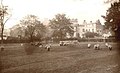
 Effra House, Brixton; with several patients walking in the g Wellcome V0013568.jpg 3,275 × 2,344; 4.09 MB
-
 Van Gogh brixton installation 16.11 (6).jpg 2,304 × 3,072; 1.48 MB
-
 Vincent van Gogh - 87 Hackford Road.jpg 1,024 × 736; 306 KB
-
 Vincent van Gogh brixton installation 16.11 (5).jpg 3,072 × 2,304; 1.5 MB


.jpg)


.jpg)


.jpg)

.jpg)


.jpg)


_-_geograph.org.uk_-_4405008.jpg)
_-_geograph.org.uk_-_4405015.jpg)


.jpg)


.jpg)


_-_October_2023.jpg)


.jpg)


.jpg)


.jpeg)


.jpg)


RP_Brixton_CLAPHAM_BUILDING_SOCIETY_Studley_Rd_STOCKWELL_London_SW9_RARE!b_POSTCARD_1908_(50272727731).jpg)


.jpg)

.jpg)