Category:Eastern Cape
Provinces of South Africa: Eastern Cape · Free State · Gauteng · KwaZulu-Natal · Limpopo · Mpumalanga · Northern Cape · North West · Western Cape
province of South Africa    | |||||
| Upload media | |||||
| Instance of | |||||
|---|---|---|---|---|---|
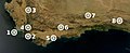
| Location | RSA | ||||
| Capital |
| ||||
| Legislative body |
| ||||
| Executive body |
| ||||
| Head of government |
| ||||
| Inception |
| ||||
| Highest point |
| ||||
| Population |
| ||||
| Area |
| ||||
| Elevation above sea level |
| ||||
| Replaces | |||||
| official website | |||||
 | |||||
Subcategories
This category has the following 25 subcategories, out of 25 total.
Media in category "Eastern Cape"
The following 26 files are in this category, out of 26 total.
-
 Cape Floral Region Protected Areas map.jpg 2,730 × 1,116; 561 KB
-
 Daily Dispatch.jpg 1,095 × 1,557; 591 KB
-
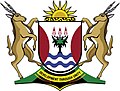 Ec coa.jpg 480 × 364; 62 KB
-
 EC coat of arms.jpg 618 × 476; 71 KB
-
 Farmhouse in a Xhosa village.jpg 720 × 716; 97 KB
-
 Kei Mouth from above.jpg 4,096 × 3,072; 6.69 MB
-
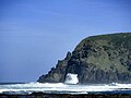 Keightley's Krantz.jpg 4,608 × 3,456; 3.98 MB
-
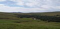 Mkemane River, Mount Frere.jpg 2,960 × 1,440; 1.1 MB
-
 Modern rondavel.jpg 715 × 536; 168 KB
-
 Mthatha Rondavels.jpg 5,616 × 3,744; 9.83 MB
-
 Ntsimangweni Location, Mount Frere (1).jpg 2,960 × 1,440; 1.5 MB
-
 Ntsimangweni Location, Mount Frere (2).jpg 2,960 × 1,440; 1.25 MB
-
 Ntsimangweni Location, Mount Frere (3).jpg 2,960 × 1,440; 1.57 MB
-
 Ntsimangweni, Mount Frere, South Africa.jpg 2,048 × 1,727; 715 KB
-
 Old kraal, Ntsimangweni, KwaBhaca, Eastern Cape Province.jpg 1,244 × 933; 368 KB
-
 Port St. Johns Beach, Eastern Cape.jpg 4,096 × 2,574; 3.06 MB
-
 Puppies in Ntsimangweni.jpg 1,440 × 2,960; 2.12 MB
-
 Road to Nieu-Bethesda.jpg 4,000 × 3,000; 3.99 MB
-
 Rondawel.jpg 2,048 × 1,228; 398 KB
-
 Rural Physiotherapy.jpg 1,440 × 1,174; 301 KB
-
 Sangoma.jpg 6,603 × 4,402; 7.44 MB
-
 Sunset at Ntsimangweni Location.jpg 2,960 × 1,440; 759 KB
-
 Thumb DJI 0036 1024.jpg 1,024 × 768; 545 KB
-
 Thumb DJI 0038 1024 2.jpg 1,024 × 768; 550 KB
-
 Tyeni.jpg 3,000 × 4,000; 4.54 MB
-
 View of Cradock, Eastern Cape, South Africa.jpg 2,619 × 1,674; 879 KB


.jpg)
.jpg)
.jpg)


