Category:Lombok Strait
English: Lombok Strait
strait in Indonesia between Bali and Lombok islands, in the eastern Lesser Sunda Islands   | |||||
| Upload media | |||||
| Instance of | |||||
|---|---|---|---|---|---|
| Named after | |||||
| Location | East Nusa Tenggara, Indonesia | ||||
| Width |
| ||||
| Length |
| ||||
| Mouth of the watercourse | |||||
 | |||||
Media in category "Lombok Strait"
The following 37 files are in this category, out of 37 total.
-
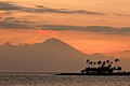 Bali's Mighty Volcanic Mount Agung seen from Senggigi Beach, Lombok.jpg 1,600 × 1,064; 605 KB
-
 Cartes des îles de Bally et Lombock- Archives nationales- 155AP-8.jpg 2,321 × 1,883; 1.39 MB
-
 Cloud over Lombok Strait, Gili Islands, West Nusa Tenggara, Indonesia.jpg 4,032 × 2,688; 5.38 MB
-
 Clouds over Lombok Strait, Boats, Gili Islands, West Nusa Tenggara, Indonesia.jpg 4,032 × 2,688; 5.68 MB
-
 Clouds over Lombok Strait, Gili Islands, West Nusa Tenggara, Indonesia.jpg 4,032 × 2,688; 5.65 MB
-

-
 Clouds, cloudscape over Lombok Strait, Gili Islands, Indian Ocean, Indonesia.jpg 4,032 × 2,688; 5.25 MB
-
 Clouds, cloudscape over Lombok Strait, West Nusa Tenggara, Indonesia.jpg 4,032 × 2,688; 5.65 MB
-
 Fishers, Late evening fishing, Gili Islands, Lombok, Indonesia.jpg 4,032 × 2,688; 6.8 MB
-
 Fishing in the sea, Fishers, Gili Islands, Lombok, Indonesia.jpg 4,032 × 2,520; 5.66 MB
-
 Fishing, Fishers, Gili Islands, Lombok, Indonesia.jpg 4,032 × 2,688; 6.17 MB
-
 Gili Islands, Boy of Indonesia smiling, Indonesian, Youth, Lombok, Indonesia.jpg 4,032 × 2,688; 6.28 MB
-
 Gili Islands, Indonesian smiling, Lombok, Indonesia.jpg 4,032 × 2,688; 5.74 MB
-
 Gili Meno and Gunung Rinjani from a boat off Gili Trawangan.jpg 800 × 480; 120 KB
-
 Gili Trawangan Island, Beach party, Twilight, Indonesia.jpg 4,032 × 2,688; 5.88 MB
-
 Gili Trawangan Island, Trees, Sunset, Indonesia.jpg 4,032 × 2,688; 6.69 MB
-
 Gili Trawangan Island, Twilight, Blue hour, Indonesia.jpg 4,032 × 2,688; 6.76 MB
-

-
 ISS009-E-7470 - View of Indonesia.jpg 3,032 × 2,064; 942 KB
-
 ISS059-E-75321 - View of Indonesia.jpg 5,568 × 3,712; 1.79 MB
-
 Lombok Strait map.jpg 412 × 231; 19 KB
-
 Lombok strait-HE.png 862 × 478; 157 KB
-
 Lombok strait.png 862 × 478; 139 KB
-
 LombokStrait.png 762 × 464; 304 KB
-
 Mountain range of Lombok Wokshots.jpg 1,920 × 1,280; 845 KB
-
 Oceanic nonlinear internal solitary waves from the Lombok Strait (MODIS 2016-11-05).jpg 2,400 × 1,800; 760 KB
-

-
 View of Lombok Island from air, Flight IU 762, 4 July 2024 001.jpg 6,000 × 4,000; 6.6 MB
-
 View of Lombok Strait from air, Flight IU 762, 4 July 2024 001.jpg 6,000 × 4,000; 5.54 MB
-
 View of Lombok Strait from air, Flight IU 762, 4 July 2024 002.jpg 6,000 × 4,000; 5.62 MB
-
 View of Lombok Strait from air, Flight IU 762, 4 July 2024 003.jpg 6,000 × 4,000; 5.71 MB
-
 View of Lombok Strait from air, Flight IU 762, 4 July 2024 004.jpg 6,000 × 4,000; 6.05 MB
-
 View of Lombok Strait from air, Flight IU 762, 4 July 2024 005.jpg 6,000 × 4,000; 6.06 MB
-
 View of Lombok Strait from air, Flight IU 762, 4 July 2024 006.jpg 6,000 × 4,000; 5.95 MB
-
 View of Lombok Strait from air, Flight IU 762, 4 July 2024 007.jpg 6,000 × 4,000; 5.91 MB
-
 View of Lombok Strait.jpg 2,816 × 2,112; 1.05 MB
-
 Zonsondergang in de straat Lombok, Bestanddeelnr 10225.jpg 3,399 × 2,682; 1.29 MB


.jpg)
.jpg)


