Category:Miura Peninsula
English: The Miura Peninsula is a peninsula located in Kanagawa, Japan. It lies southwest of Yokohama and divides Tokyo Bay, to the east, from Sagami Bay, to the west.
peninsula in Japan     | |||||
| Upload media | |||||
| Instance of | |||||
|---|---|---|---|---|---|
| Named after |
| ||||
| Location | Kanagawa Prefecture, Japan | ||||
| Located in or next to body of water | |||||
| Highest point | |||||
 | |||||
Subcategories
This category has the following 4 subcategories, out of 4 total.
Media in category "Miura Peninsula"
The following 18 files are in this category, out of 18 total.
-
 17 - The Sea off the Miura Peninsula.jpg 5,810 × 8,340; 6.78 MB
-
 Aerial Mount Fuji (52133194691).jpg 5,773 × 3,849; 7.27 MB
-

-
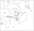
 Location MiuraPeninsulaJp.jpg 647 × 702; 61 KB
-
 Miura Peninsula fault 1.gif 543 × 500; 33 KB
-
 Miura Peninsula Kanagawa Japan SRTM.jpg 747 × 773; 125 KB
-
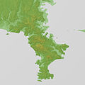 Miura Peninsula Relief Map, SRTM-1.jpg 1,600 × 1,600; 806 KB
-
 Miura peninsula.jpg 1,600 × 1,200; 497 KB
-
 Moroisoinlet.png 382 × 233; 109 KB
-
 Mount Fuji as seen from Shonan village 2017-11-03.jpg 5,472 × 3,648; 3.15 MB
-
 Obaradai Yokosuka aerial.jpg 2,154 × 1,492; 1.46 MB
-
 STS107-E-5256 - View of Japan.jpg 2,008 × 3,024; 1.21 MB
-
 STS107-E-5257 - View of Japan.jpg 2,008 × 3,024; 940 KB
-
 Sōshū miura no kaijō LCCN2008660256.jpg 713 × 1,024; 134 KB
-
 Tateishi park.JPG 4,000 × 3,000; 2.38 MB
-
 三浦郡誌.pdf 1,750 × 1,237, 131 pages; 36.5 MB
-
 京急衛星画像100南.jpg 460 × 608; 78 KB
-


.jpg)
.jpg)


,_from_the_series_Thirty-six_Views_of_Mount_Fuji_(Fugaku_sanj%C5%ABrokkei)_MET_DP120497.jpg)