Category:Salar de Coipasa
 | |||||
| Upload media | |||||
| Instance of | |||||
|---|---|---|---|---|---|
| Location |
| ||||
| Width |
| ||||
| Length |
| ||||
| Area |
| ||||
| Elevation above sea level |
| ||||
| Inflows |
| ||||
 | |||||
English: Salar de Coipasa (Coipasa Lake) — an endorheic salt lake and salt flats in the Oruro Department, on the Altiplano de Bolivia in southeastern Bolivia.
Subcategories
This category has the following 3 subcategories, out of 3 total.
Media in category "Salar de Coipasa"
The following 12 files are in this category, out of 12 total.
-
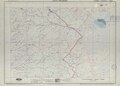 19°S-MP0001299.pdf 4,468 × 3,200; 2.27 MB
-
 Coipasa lake map of the shape and depth (bathymetry) 2020.jpg 720 × 545; 93 KB
-
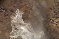 ISS015-E-9289 - View of Chile.jpg 3,032 × 2,008; 1 MB
-
 Lago Uru Uru Chipaya 1.jpg 1,200 × 760; 632 KB
-
 Lago Uru Uru Chipaya 2.jpg 797 × 1,200; 675 KB
-
 Lago Uru Uru Chipaya 3.jpg 797 × 1,200; 575 KB
-
 Lago Uru Uru Chipaya 4.jpg 1,200 × 722; 390 KB
-
 Lago Uru Uru Chipaya 5.jpg 1,200 × 797; 627 KB
-
 Lago Uru Uru Chipaya 6.jpg 797 × 1,200; 560 KB
-
 Lago Uru Uru Chipaya 7.jpg 817 × 1,200; 674 KB
-
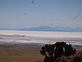
 Tunupa Volcano, Bolivia from ISS.jpg 720 × 480; 300 KB
-
 Vista panorámica del salr de Coipasa. - panoramio.jpg 4,608 × 3,456; 6.43 MB
_2020.jpg)


