Category:Torishima
island in Tokyo, Japan Torišima | |||||
| Upload media | |||||
| Instance of | |||||
|---|---|---|---|---|---|
| Part of | |||||
| Named after | |||||
| Location | Hachijō Subprefecture, Tokyo, Japan | ||||
| Located in or next to body of water | |||||
| Heritage designation | |||||
| Significant event |
| ||||
| Width |
| ||||
| Length |
| ||||
| Highest point |
| ||||
| Population |
| ||||
| Area |
| ||||
| Elevation above sea level |
| ||||
| official website | |||||
 | |||||
English: Category for Torishima (Tori Island) in the Izu Islands, Tokyo, Japan
日本語: 伊豆諸島・鳥島に関するカテゴリ
Subcategories
This category has the following 3 subcategories, out of 3 total.
Media in category "Torishima"
The following 16 files are in this category, out of 16 total.
-
 Izu Torishima.PNG 756 × 546; 496 KB
-
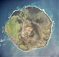 Tori-Shima Island of Izu-Islands Aerial photograph.2001.jpg 3,335 × 3,221; 2.66 MB
-
 Tori-Shima Island of Izu-Islands Aerial photograph.jpg 5,197 × 4,143; 28.36 MB
-
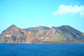 Torishima 07 02.jpg 1,500 × 1,000; 273 KB
-
 Torishima 07 03.jpg 1,500 × 1,100; 511 KB
-
 Torishima 07.jpg 564 × 423; 32 KB
-
 Torishima 2007-01.jpg 1,500 × 1,100; 270 KB
-
 Torishima 20250512 130155.jpg 4,608 × 2,592; 2.51 MB
-
 Torishima 20250515 105803.jpg 4,608 × 2,592; 3.05 MB
-
 Torishima 20250515 111328.jpg 4,608 × 2,592; 1.91 MB
-
 Torishima 20250515 113135.jpg 4,608 × 2,592; 2.93 MB
-
 Torishima 20250515 115531.jpg 4,608 × 2,592; 2.14 MB
-
 Torishima castaway.png 1,500 × 1,000; 103 KB
-
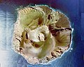
 Torishima mlit.jpg 1,024 × 1,193; 151 KB
-
 Torishima schematic map.jpg 1,400 × 1,200; 266 KB
-
 Остров Панафидина.png 619 × 618; 59 KB
